Search Results
99 results found with an empty search
- Kishwaukee Gorge South | Winnebago Forest
< Back Kishwaukee Gorge South 6915 Faust Lane, Cherry Valley, IL 61016 Public access is provided from the private Faust Lane off Rotary Road. This 49.6-acre preserve is currently undeveloped. Acres: 49.6 Access Road: No Restrooms: No Drinking Water: No Picnic Tables: No Shelterhouses: No Playground Equipment: No Ball Fields: No Horseback Trails: No Hiking Trails(miles): 0.0 Campground Sites: No Boat Launch: No Canoe Launch: No 18 Hole Golf Course: No Illinois Nature Preserve: No Special Facilities: No Donated Land: No Natural Areas: Yes All reservations subject to the GENERAL USE ORDINANCE. Previous Next
- Ledges | Winnebago Forest
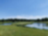
< Back Ledges 7111 McCurry Road, Roscoe, IL 61073 Scenic and challenging 18-hole golf course. Built as a private course in 1966, this course was purchased by the District in 1978. Fairway bunkers and sand traps test your skill and accuracy. In addition, water hazards are featured on 10 holes. Area golfers are now enjoying this challenging course that often requires the use of every club in your bag. Tee times may be reserved online at playthepreserves.com. Acres: 185 Access Road: Yes Restrooms: Yes Drinking Water: Yes Picnic Tables: Yes Shelterhouses: No Playground Equipment: No Ball Fields: No Horseback Trails: No Hiking Trails(miles): 0.0 Campground Sites: No Boat Launch: No Canoe Launch: No 18 Hole Golf Course: Yes Illinois Nature Preserve: No Special Facilities: Clubhouse, Pro Shop Donated Land: No Natural Areas: No All reservations subject to the GENERAL USE ORDINANCE. Previous Next
- R. Robert Funderburg | Winnebago Forest
< Back R. Robert Funderburg 4551 S. Meridian Road, Rockford IL, 61102 Funderburg Forest Preserve’s 868.6 acres provides valuable wildlife habitat and is home to a variety of plant species and numerous species of birds. Located adjacent to Severson Dells Forest Preserve and also connecting to the Byron Forest Preserve District’s Howard Coleman Hall Creek Preserve and Natural Land Institute’s Coleman Dells Nature Preserve. This area offers a unique opportunity for three land organizations to preserve and manage one large contiguous piece of land where plant and wildlife can thrive in an uninterrupted habitat area. Currently there is a network of hiking trails, offering preserve users opportunities for shorter or longer hikes based on available time and abilities through mild to moderate terrain. Acquired in 2020 with financial assistance provided by and in cooperation with the Illinois Clean Energy Community Foundation, the preserve is under development. Future plans for the preserve include converting crop farmed areas to prairie and savannah type habitat and preservation of the existing woodlands. Seasonal Highlights: R. Robert Funderburg Forest Preserve is a prime spot for observing birds during spring and fall migrations as well as viewing spectacular autumn colors in the forested areas. Acres: 868.6 Access Road: Yes Restrooms: No Drinking Water: No Picnic Tables: No Shelterhouses: No Playground Equipment: No Ball Fields: No Horseback Trails: No Hiking Trails (miles): 8 Campground Sites: No Boat Launch: No Canoe Launch: No 18 Hole Golf Course: No Illinois Nature Preserve: No Donated Land: No Natural Areas: Yes Previous Next
- Kilbuck Bluffs | Winnebago Forest
< Back Kilbuck Bluffs 3061 & 3020 South Bend Road, Rockford, IL 61109 Kilbuck Bluffs Forest Preserve is one of the oldest in Winnebago County. This 224.3-acre preserve consists of two parts along South Bend Road. The west portion has a road that loops around in the floodplain of Kilbuck Creek. Very large cottonwood, oak and other trees cover the area creating an ideal spot for bank fishing the creek. In early spring the ground here becomes covered with Spring Beauties. The white and purple streaked flowers light up the flats. Across the road and high atop a hill is the east portion of Kilbuck Bluffs Forest Preserve. This is the part that gives the name to the preserve. Kilbuck Creek flows rapidly along the bluff just to the south. The loop roadway leads around through hardwood forest and a grove of pine trees planted in the 1950’s. If you are visiting this side of the forest preserve in the spring check out the flowers of the forest floor. You’ll want to step carefully among the beds of May Apples, Bloodroots, Dutchman’s Breeches, and Virginia Cutleaf. Return a couple weeks later to a flood of blue Virginia Bluebells covering the floor of the forest. The displays of ephemeral flowers make Kilbuck “a must” for spring hikes. 1.5 miles of hiking trails make a nice tour of the creek, bluff, prairie and woods. Along with the flowers and early insects, come the migrant birds. Looking over the edge of the bluff, into the branches of eye-level trees, brings the bird life very close. Kilbuck is a great spot to find birds during spring migration. Woodland birds from thrushes, tanagers, woodpeckers, vireos, and warblers are common. Acres: 224.3 Access Road: Yes Restrooms: Yes Drinking Water: Yes Picnic Tables: Yes Shelterhouses: 2 Edgewood: South on left. Wood shelter, 100 max. people, 10 tables, 60 seats, No electricity, No vehicle access, 1 large grill. Fort Chartres: Stone shelter no longer in use. Playground Equipment: No Ball Fields: No Horseback Trails: No Hiking Trails(miles): 1.5 Campground Sites: No Boat Launch: No Canoe Launch: No 18 Hole Golf Course: No Illinois Nature Preserve: No Special Facilities: No Donated Land: No Natural Areas: Yes All reservations subject to the GENERAL USE ORDINANCE. Previous Next
- Sugar River | Winnebago Forest
< Back Sugar River 10127 Forest Preserve Road, Durand, IL 61024 Sugar River Forest Preserve, nestled among beautiful woods and prairie on the banks of the Sugar River, is one of the most scenic in Winnebago County. Its 529 acres comprise one of the most serene and unspoiled spots in northern Illinois. Ecological features include a braggingly pure river filled with wetland creatures (many endangered) and sandy bluffs that create small beaches along it. As well as dense forest with tall pines, and sandy prairie, all of this surrounded by the quiet countryside of northern Illinois makes Sugar River Forest Preserve a popular place for humans and animals alike! This quiet preserve offers a variety of habitats to hike and canoe. Explore woodlands, sand prairie, wetlands and river. Sugar River is the site of FPWC’s primitive camping area for tent camping right along the river, and offers a campground with electric sites and showerhouse, as well. The 5.9-mile trail system at Sugar River Forest Preserve travels the entire preserve from the south end with restored prairie, up through forest and wetland, with such a mesmerizing array of colorful birds it could make anyone consider taking up birding as a hobby. Acres: 529 Access Road: Yes Restrooms: Yes Drinking Water: Yes Picnic Tables: Yes Shelterhouses: 2 River View: Stone shelter with fireplace, 80 max. people, 8 tables, 48 seats, No electricity, vehicle access. Sand Bluffs: Wood shelter, 132 max. people, 16 tables, 96 seats, No electricity, Vehicle access. Playground Equipment: Yes Ball Fields: No Horseback Trails: Yes Hiking Trails(miles): 5.9 Campground Sites: 82 Boat Launch: No Canoe Launch: Yes 18 Hole Golf Course: No Illinois Nature Preserve: No Special Facilities: Youth/Scout Camp Donated Land: No Natural Areas: Yes All reservations subject to the GENERAL USE ORDINANCE. Previous Next
- Grove Creek | Winnebago Forest
< Back Grove Creek 18319 W. State St., Pecatonica, IL 61063 The preserve access is not yet established. The district is seeking approval to connect with trails in Seward Bluffs under U.S. Hwy 20 from IDOT. If granted a trail connection the district intends to establish a parking area along Klinger road for this preserve. Acres: 80.5 Access Road: No Restrooms: No Drinking Water: No Picnic Tables: No Shelterhouse: No Playground equipment: No Ball Fields: No Horseback Trails: No but with approval from IDOT will connect with Seward Bluff trails Hiking Trails(miles): No – Seeking permission for trail under U.S. Hwy 20 to connect with Seward Bluffs Campground Sites: No Boat Launch: No Canoe Launch: No 18 Hole Golf Course: No Natural area: Yes adjacent to Wilson Prairie Nature Preserve Previous Next
- Items (All) (Item) | Winnebago Forest
Forest Preserves Atwood Homestead 8990 Old River Road, Rockford, IL 61103 Read More Blackhawk Springs 5360 Mulford Road & 5801 Perryville Rd, Cherry Valley, IL 61016 Read More Cedar Cliff 7901 Kishwaukee Road, Stillman Valley, IL 61084 Read More Clayton Andrews 8399 Kiowa Crossing, Roscoe, IL 61073 Read More Colored Sands 10602 Haas Road, Rockton, IL 61024 Read More County Line 7530 Ipsen Road Belvidere, IL 61008 Read More Crooked River 16394 Anderson Road Pecatonica, IL 61063 Read More Deer Run 5691 River Road, Cherry Valley, IL 61016 Read More District Map - Forest Preserves of Winnebago County View all 44 preserves on our District Map! Read More Espenscheid Memorial 4800 South Perryville Road, Cherry Valley, IL 61016 Read More Ferguson 8602 West Winslow Road, Shirland, IL 61079 Read More Four Lakes 10207 Fish Hatchery Road, Pecatonica, IL 61063 Read More Fuller Memorial 6700 Fitzgerald Road, Rockford, IL 61102 Read More Grove Creek 18319 W. State St., Pecatonica, IL 61063 Read More Hartley Memorial 14990 Campbell Road, Durand, IL 61024 Read More Headquarters 5500 Northrock Drive, Rockford, IL 61103 Read More Hinchliff Memorial 6770 Kishwaukee Road, Rockford, IL 61109 Read More Hononegah #80 Hononegah Road, Rockton, IL 61072 Read More Indian Hill 7061 Kishwaukee Road, Rockford, IL 61109 Read More J. Norman Jensen 14400 S. Bluff, Rockton, IL 61072 Read More Kieselburg 5801 Swanson Road, Roscoe, IL 61073 Read More Kilbuck Bluffs 3061 & 3020 South Bend Road, Rockford, IL 61109 Read More Kishwaukee Gorge North 4643 Blackhawk Road, Cherry Valley, IL 61016 Read More Kishwaukee Gorge South 6915 Faust Lane, Cherry Valley, IL 61016 Read More Kishwaukee River 6303 Mulford Road & 5757 Blackhawk Road, Cherry Valley, IL 61016 Read More Klehm Forest Preserve 2715 S. Main Street, Rockford, IL 61102 Read More Laona Heights 15402 Anderson Road, Durand, IL 61024 Read More Ledges 7111 McCurry Road, Roscoe, IL 61073 Read More Macktown 2221 Freeport Road, Rockton, IL 61072 Read More McKiski 3808 Genoa Road, Cherry Valley, IL 61016 Read More Millrace Isle 2600 W. Rockton Road, Rockton, IL 61072 Read More Oak Ridge 8322 Blomberg Road, Cherry Valley, IL 61016 Read More Pecatonica River 7260 Judd Road & 14960 Brick School Road, Pecatonica, IL 61063 Read More Pecatonica Wetlands 5750 Best Road, Pecatonica, IL 61063 Read More R. Robert Funderburg 4551 S. Meridian Road, Rockford IL, 61102 Read More Rockford Rotary 5390 Rotary Road, Cherry Valley, IL 61063 Read More Roland Olson 9669 Atwood Road, Roscoe, IL 61073 Read More Severson Dells 8786 Montague Road, Rockford, IL 61102 Read More Seward Bluffs 16999 Comly Road, Seward, IL 61077 Read More Stone Bridge 6119 Burr Oak Rd., Roscoe, IL 61073 Read More Sugar River 10127 Forest Preserve Road, Durand, IL 61024 Read More Sugar River Alder 10255 Haas Road, Shirland, IL 61079 Read More Trailside 2161 Baxter Road, Rockford, IL 61109 Read More Trask Bridge 11532 Trask Bridge Road, Rockford, IL 61101 Read More Two Rivers 12251 Harrison Road, Durand, IL 61024 Read More
- Hinchliff Memorial | Winnebago Forest
< Back Hinchliff Memorial 6770 Kishwaukee Road, Rockford, IL 61109 Acres: 2 Access Road: No Restrooms: No Drinking Water: No Picnic Tables: Yes Shelterhouses: No Playground Equipment: No Ball Fields: No Horseback Trails: No Hiking Trails(miles): 0.0 Campground Sites: No Boat Launch: No Canoe Launch: Yes 18 Hole Golf Course: No Illinois Nature Preserve: No Special Facilities: No Donated Land: Yes Natural Areas: No All reservations subject to the GENERAL USE ORDINANCE. Previous Next
- Two Rivers | Winnebago Forest
< Back Two Rivers 12251 Harrison Road, Durand, IL 61024 Two Rivers is one of the District’s smaller preserves and is used primarily for canoe access to the Pecatonica and Sugar Rivers. Other recreational opportunities include picnicking and fishing. Accessible from Harrison Road. Acres: 6.5 Access Road: Yes Restrooms: Yes Drinking Water: Yes Picnic Tables: Yes Shelterhouses: Small non-reservable shelter Playground Equipment: No Ball Fields: No Horseback Trails: No Hiking Trails(miles): 0.0 Campground Sites: No Boat Launch: 1 Canoe Launch: Yes 18 Hole Golf Course: No Illinois Nature Preserve: No Special Facilities: No Donated Land: No Natural Areas: No All reservations subject to the GENERAL USE ORDINANCE. Previous Next
- Ferguson | Winnebago Forest
< Back Ferguson 8602 West Winslow Road, Shirland, IL 61079 Ferguson Forest Preserve’s 529 acres provides valuable wildlife habitat and is home to several threatened plant species and about 150 species of birds. Located at the confluence of the Sugar River and Pecatonica Rivers, it is one of the best migratory bird locations in the county. A diversity of waterfowl can be seen including Sandhill cranes, and several different species of ducks. Bald eagles, owls and songbirds are often seen here. There are many wet and open water areas, restored prairie, and some woodland. Ferguson’s low-lying floodplain habitat often floods after heavy rain and snowmelt. At present there is one perimeter hiking trail which offers interpretive signage about the ecology, history and wildlife of this river confluence. Acquired in 2014, the preserve is under development. Seasonal Highlights: Ferguson Forest Preserve is a prime spot for observing waterfowl and wading birds during spring and fall migrations. In spring a frog chorus calls fill the air and in summer the prairie blooms with an array of native flowers and shelters nesting grassland birds. Acres: 529.3 Access Road: Yes Restrooms: Yes Drinking Water: No Picnic Tables: No Shelterhouses: No Playground Equipment: No Ball Fields: No Horseback Trails: No Hiking Trails(miles): 3.1 Campground Sites: No Boat Launch: No Canoe Launch: No 18 Hole Golf Course: No Illinois Nature Preserve: No Donated Land: Yes Natural Areas: Yes Previous Next
- Kishwaukee Gorge North | Winnebago Forest
< Back Kishwaukee Gorge North 4643 Blackhawk Road, Cherry Valley, IL 61016 Kishwaukee Gorge Forest Preserve (North) contains some of the most interesting geology in Winnebago County. It offers a hiker’s paradise of diverse woodlands, prairie openings and rugged ravines. This preserve is home to a restored prairie, deep forest with large, statuesque twisted oak trees, and steep-sided gorges leading down to a peaceful opening on the Kishwaukee River. Nearly three miles of relatively easy hiking trail consist of mowed grass around the prairie, and a rather rugged dirt path in the forest. The trail becomes a bit challenging when climbing down and up the fifty or so steep, man-made steps along the side of the gorge that lead to its bottom, and the Kishwaukee River. Seasonal Highlights at Kishwaukee Gorge North A high up fenced lookout provides nice summer views out over the gorge. Sit down on the bench here and relax up in the tops of the trees with the birds, the river just visible deep down through the thick forestry. Late summer is peak bloom for the diverse prairie flowers, and fall prairie grasses offer a tapestry of rich color and texture. The fall foliage is spectacular. The golden leaves of maples, the russets of old oaks, red sumac, set against a background of sparkling blue river. In winter, cross-county skiing may be enjoyed on Kishwaukee Gorge’s mowed trails. All FPWC cross-country ski trails are ungroomed. The access road allows room for skiers to park their cars off the roadway in front of the locked gates. Acres: 127.6 Access Road: Yes Restrooms: Yes Drinking Water: No Picnic Tables: Yes Shelterhouses: No Playground Equipment: No Ball Fields: No Horseback Trails: No Hiking Trails(miles): 3.1 Campground Sites: No Boat Launch: No Canoe Launch: No 18 Hole Golf Course: No Illinois Nature Preserve: No Special Facilities: No Donated Land: No Natural Areas: Yes All reservations subject to the GENERAL USE ORDINANCE. Previous Next
- Blackhawk Springs | Winnebago Forest
< Back Blackhawk Springs 5360 Mulford Road & 5801 Perryville Rd, Cherry Valley, IL 61016 One of Winnebago County’s largest forest preserves, this 629.9-acre tract is heavily wooded, and provides a wealth of fishing and hiking activities. Blackhawk Springs has 7.5 miles of easy to moderate hiking trails, and a 2.3-mile scenic, paved recreation path. Walking the trails here will lead you to an exploration of flower-filled prairies, cool shady woodlands, the glistening Kishwaukee River, and a lovely little bubbling natural spring. The beautiful and healthy Kishwaukee River makes this preserve a favorite destination in summer. Whether you want to enjoy the flowing stream as you hike, bike, jog or push a stroller on the paved path, or sit on the shady bank and fish, this is an ideal spot to enjoy rippling waters. And don’t forget to visit in the winter when the paved trail is cleared of snow offering a nice opportunity for walkers and joggers to enjoy the outdoors year-round. Seasonal Highlights: Woodland wildflowers are a spring treat in the mature woods on the east side of the preserve. May is the best time to see trilliums, jack-in-the-pulpits, may apples, and other shade-loving early blooms. Blackhawk Springs is an excellent site for birdwatching, especially during the spring and fall migrations. Look for Osprey and Bald Eagles fishing in the river. Acres: 629.9 Access Road: Yes Restrooms: Yes Drinking Water: Yes Picnic Tables: Yes Shelterhouses: 1 Indian Springs: 300 max. people, 25 tables, 150 seats, Electricity, No vehicle access, 30 more tables in the area for a total of 300 people. Playground Equipment: Yes Ball Fields: Yes Horseback Trails: No Hiking Trails(miles): 7.5 Paved Trail:2.3 Campground Sites: No Boat Launch: No Canoe Launch: No 18 Hole Golf Course: No Illinois Nature Preserve: No Special Facilities: Paved Recreation Trail Donated Land: No Natural Areas: Yes All reservations subject to the GENERAL USE ORDINANCE. Previous Next